


03-05-2019 3 journée 30,2km

dudu85
User

Length
26 km

Max alt
26 m

Uphill gradient
214 m
Km-Effort
29 km

Min alt
2 m

Downhill gradient
214 m
Boucle
No
Creation date :
2019-05-03 07:38:40.0
Updated on :
2019-05-03 14:59:37.463
6h36
Difficulty : Unknown

FREE GPS app for hiking
 SityTrail
IGN / Geographical institutes
SityTrail Plus
The world is yours!
About
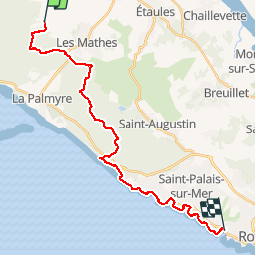
Trail Walking of 26 km to be discovered at New Aquitaine, Charente-Maritime, Les Mathes. This trail is proposed by dudu85.
Description
Randonnée mixte foret GR4 et bord de mer.
Départ de Dirée commune d’Alvert) Arrivée Royal
Positioning
Country:
France
Region :
New Aquitaine
Department/Province :
Charente-Maritime
Municipality :
Les Mathes
Location:
Unknown
Start:(Dec)
Start:(UTM)
641963 ; 5065410 (30T) N.
Comments